A house plan shows the home you want. A residential site plan connects that design to the actual parcel. It accounts for local zoning, drainage, flood, and permitting requirements.
Before you buy land, choose a model, or start an addition, review how the home fits the property. County and municipal requirements vary. This article is educational, not a substitute for a current survey, licensed surveyor, engineer, or local permitting authority.
Here is how to read it with confidence before construction begins.
What a Residential Site Plan Tells You
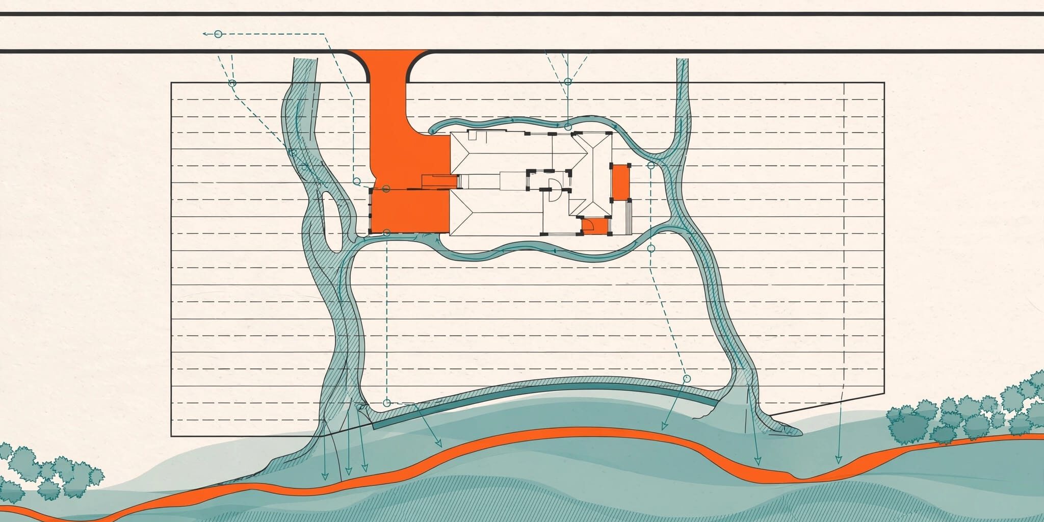
A site plan is a top-down drawing of the property. It helps homeowners and prospective buyers see where the house, driveway, utilities, outdoor features, and drainage areas sit within the lot.
For building permits, reviewers often rely on this site plan for new homes, pools, garages, additions, and substantial outdoor work. It connects the design to actual land while helping reviewers evaluate zoning requirements, access, utilities, flood exposure, and stormwater management. It distinguishes existing structures from proposed structures and identifies accessory structures, such as pools, sheds, detached garages, and screened enclosures.
A Site Plan Is Different From a Floor Plan
A floor plan shows rooms, doors, windows, closets, and interior dimensions. It helps you understand how you will live inside the home.
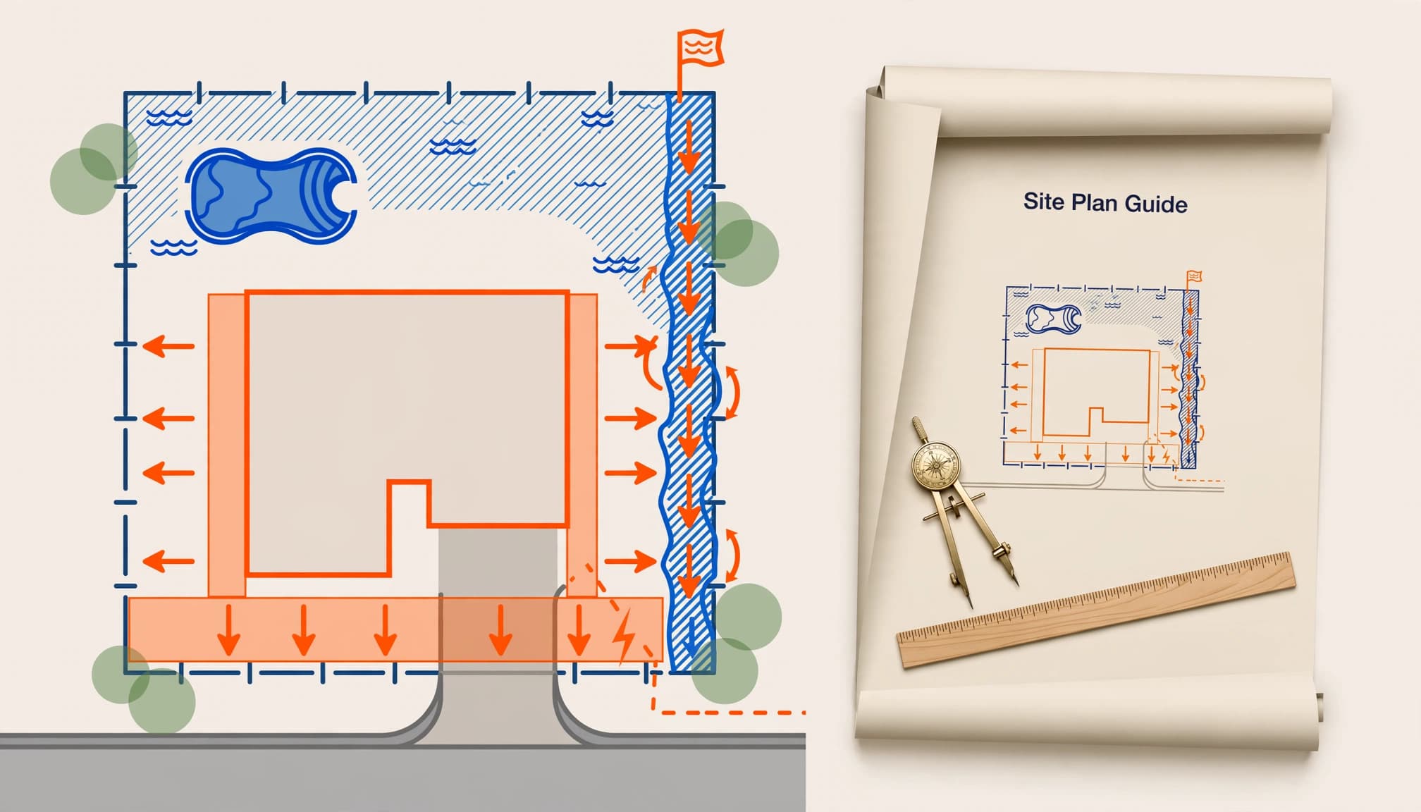
This drawing shows the parcel-level relationship among the house footprint, driveway, utility connections, drainage features, easements, and street access.
You need both drawings for many projects. One explains the layout of the home. The other shows where that home belongs on the parcel.
The Property Is Part of the Permit Review
A beautiful floor plan can still create problems if the house sits too close to a property line or blocks a drainage route. A narrow lot may limit the home’s width. A flood-zone requirement may raise the finished floor and change the driveway slope.
Lee County’s residential permit requirements call for a scaled plot plan that identifies lot corners, dimensions, street names, setbacks, driveways, easements, roof lines, foundations, and existing or proposed buildings. That checklist is an example, not a universal rule. Confirm current permit details and local zoning rules with the exact county or municipality governing the property.
Read the Residential Site Plan From Outside In
Start at the edge of the site plan, then work toward the house footprint. This outside-in order keeps you from missing details that control where construction can happen.
Find Property Lines, Corners, and Street Frontage
Begin with the lot boundary, property lines, corners, street frontage, and lot dimensions. Look for solid boundary lines, measured dimensions, iron rods, lot corners, and the name of the bordering street or road.
Don’t rely on GIS data, satellite imagery, tax maps, listing graphics, or fences to establish legal property lines. Fences can sit inside a lot, cross a boundary, or follow an older layout.
A current property survey establishes the legal boundary. If that boundary affects construction, consult a surveyor before proceeding.
Check the lot shape, too. A rectangular parcel is easier to read than an irregular waterfront or pie-shaped lot. Every angle and narrow point can affect the buildable area.
Read the North Arrow, Scale, and Legend
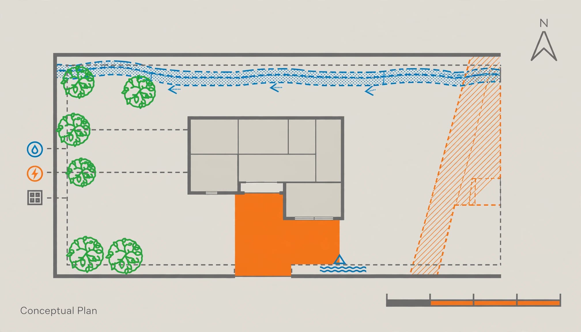
The north arrow shows direction. It helps you interpret sun exposure, canal or road orientation, driveway location, rear-yard shade, and the relationship to a neighboring home.
Read the drawing as a scale drawing, where measured distances correspond to real-world dimensions. In Lee County, the minimum required scale for a residential plot plan is 1/8 inch equals 1 foot. Other jurisdictions may use different requirements. A site plan without a reliable scale shouldn’t be used to judge clearances.
The legend explains symbols, line types, and abbreviations. Identify markings for existing versus proposed work, utilities, drainage, wetlands, septic or well notes, tree preservation areas, and flood-related information. These details can affect accessory structures, pools, lanais, and driveway changes.
Find Setbacks, Easements, and Buildable Space
The clear space between the structure and the property lines often matters more than the overall lot size shown on a site plan. A larger lot doesn’t always provide more buildable space.
Measure Building Setbacks From the Closest Point
These required open areas are measured from the applicable property boundary to the closest permitted portion of an improvement. On a site plan, they usually appear as dimension lines between the boundary and the nearest part of the home.
Local rules may count a roof overhang, porch, garage corner, pool structure, screened enclosure, wall, or another projection. Lee County measures setbacks from the closest point of the building to the closest point of the property line.
Zoning requirements vary by district, municipality, parcel shape, waterfront status, and project type. Highlands County materials show a 25-foot front, 10-foot side, and 25-foot rear example for one district. That example isn’t a countywide rule, so confirm dimensions with the applicable county or city land-development and permitting authority.
A neighbor’s house isn’t proof that your proposed home can sit in the same location. It may have been built under different zoning, older codes, or approved conditions.
Watch for Easements and Rights-of-Way
An easement gives another party a legal right to use part of the property. Easement areas may restrict placement even when they look usable.
Utility easements may allow access for utility connections to water, sewer, electric, communications, or drainage infrastructure. Drainage easements can carry stormwater across or beside your lot, and tree preservation rules may protect vegetation there.
The right-of-way is the public area along the street. Driveway crossings, culverts, sidewalk work, or mailbox placement may require review beyond the house permit.
On waterfront lots, look for seawall notes, mean high water lines, and access limitations. Charlotte County requires this information for proposed structures, setbacks, easements, driveway review, and waterfront conditions where they apply.
Review Drainage, Elevation, and Flood Notes
Southwest Florida rain can expose a weak site plan fast. A home may look fine during a dry-weather walkthrough, then hold water beside the foundation after the first heavy storm. Here, drainage patterns often reveal problems that dry conditions conceal.
Follow Water Across the Lot
Follow arrows showing flow across the lot. Review swales, culverts, retention or detention areas, spot elevations, topographic contours, and drainage easements. Check the relationship between the house, driveway, neighboring lots, canals, and streets. The site plan should show where runoff goes without harming the home or nearby property.
An impervious surface includes roofs, driveways, patios, pool decks, and other hardscape that affects stormwater management. These features reduce infiltration and can change where runoff travels.
Add the horizontal area of each hardscape feature, divide the total by lot area, and multiply by 100. Use that percentage only as an initial screening tool. Local county, municipal, water-management-district, and floodplain requirements control what is allowed and what drainage work is needed.
The Southwest Florida Water Management District oversees water-resource work across its service area. The county or city reviewing your permit sets parcel-specific requirements.
Check Finished-Floor and Flood Information
Look for the flood-zone designation, FEMA map panel, Base Flood Elevation (BFE), design flood elevation, existing grade, proposed grade, and finished-floor elevation. These numbers can affect the foundation, garage approach, utilities, insurance, and overall site budget.
Existing grade is the ground surface before construction. Finished grade is the proposed surface around the structure after grading.
Finished-floor elevation identifies the floor’s height above the reference datum. BFE is the mapped flood level for the area, while design flood elevation may reflect a higher local or project standard.
In Lee County Special Flood Hazard Areas, the county’s Residential Guide sets the minimum elevation. The lowest floor must be at least one foot above BFE or the design flood elevation, whichever is higher. This is a Lee County requirement, not a statewide rule. The guide also identifies when an Elevation Certificate is required.
Verify current requirements with the governing county, municipality, FEMA mapping, and applicable water-management authority.
Zone X doesn’t eliminate localized flooding, canal impacts, blocked drainage, or insurance questions. Local grading, nearby canals, stormwater paths, and driveway elevations still matter.
Wetlands, septic or well areas, and utility corridors can limit grading and change stormwater design.
Review the finished grade where the driveway meets the street and where drainage transitions away from the home. A lower-priced lot isn’t a bargain if added fill, drainage work, engineering, or a raised foundation was never included in the budget.
Know When a Survey or Engineer Is Required
You can draw a simple site plan to explore ideas. You should not treat that drawing as a replacement for documents requiring a licensed professional.
A Concept Drawing Can Start the Conversation
A basic drawing is useful when you want to compare home placement, driveway options, a future pool, or a room addition. Start with recorded lot dimensions, a current property survey, and clear measurements for every proposed feature.
That survey is more reliable than listing maps or informal measurements. Use the drawing to ask better questions before you commit. Does the garage fit? Is there room for side-yard access? Will the lanai remain inside the rear setback? Where will the air-conditioning equipment and utilities sit?
For final approval, the building department may require more detail than a homeowner-created plan can provide.
Sealed Documents Protect the Project
Charlotte County requires a signed and sealed survey that is less than one year old for its single-family residential package. Its single-family permit guidance also calls for flood-zone information, a topographic survey with topographic contours, existing and proposed elevations, and final-floor information.
A surveyor or engineer may need to verify those elevations and finished grade. That review can cover the home, driveway, drainage system, or foundation.
Lee County may require a certified sealed survey for coastal-zone property. Work in a regulatory floodway can also require a No-Rise or No-Impact Certification signed and sealed by a Florida-licensed engineer. Requirements vary by county, municipality, project scope, and flood zone.
Bring in a surveyor, engineer, or design professional when boundaries, flood elevations, drainage, wetlands, or regulatory floodways affect the project. Professional review may also be needed for coastal or waterfront conditions, septic or well locations, utility conflicts, and retaining or foundation work. A plan may need sealed survey, engineering, floodplain, or environmental documentation before a permit application can be approved. This article can’t replace a surveyor, engineer, architect, or local permitting authority. Correcting a plan before construction is easier than correcting it after concrete is placed.
Check the Plan Before You Submit or Buy
Review the site plan before you buy land or sign a construction agreement. This can prevent expensive changes and help you request building permits with the right information. Keep the current survey, elevation records, inspection reports, and written county decisions together.
Before purchasing land, signing a construction agreement, or submitting a permit application, compare the site plan with the current survey and county checklist:
- The legend, north arrow, scale, lot dimensions, and property lines are clear and match the current survey.
- The plan separates existing structures, proposed structures, and accessory structures, including pools, patios, sheds, and driveways.
- Building setbacks, easements, wetlands, and septic or well notes match the county checklist and zoning requirements.
- Drainage routes, stormwater management features, and utility connections are clearly shown.
- Public street access, the right-of-way, culverts, sidewalks, and driveway permits support the driveway location.
- Tree preservation, planted areas, hardscape, and landscape design are accounted for, since they can affect the usable layout.
- The flood zone, map panel, BFE, existing grade, proposed finished grade, finished-floor elevation, driveway transitions, and required certificates match the current parcel review.
Charlotte County’s single-family permitting overview states that three plans are required. Always confirm the current checklist with the exact city or county governing the parcel. A checklist can’t resolve a boundary, elevation, engineering, wetlands, septic, well, or floodplain issue by itself.
Key Takeaways
A residential site plan connects your home design to a buildable lot. Read the legend, north arrow, scale, lot boundaries, setbacks, easements, drainage, and elevation notes.
Verify utility locations, driveway access, wetlands, septic or well notes, and flood-zone information. Before relying on the plan, ask a qualified professional or local authority to confirm unclear details.
The best plan is one that fits your home, property, budget, and local requirements.
Frequently Asked Questions
When Is a Site Plan Needed for a Home Project?
New construction usually requires this document. You may also need one for an addition, pool, detached structure, driveway work, major patio, or another project that changes the property’s layout.
Requirements vary by county and municipality. Confirm the local permit checklist before paying for final drawings. A current survey, engineer, or floodplain review may also be required.
Can You Draw Your Own Residential Site Plan?
You can prepare a preliminary layout to discuss ideas and compare options. For permit approval, a current survey, certified documents, sealed professional drawings, or engineering may be required.
Don’t copy property lines from a listing, tax record, or online map and treat them as final. Those sources can help with early research, but they don’t replace a legal survey. The local permitting office can confirm which documents your project needs.
How Do You Read the Legend, North Arrow, and Site Notes?
A legend explains the drawing’s symbols. The north arrow shows orientation, while the scale shows distances. Compare the lot lines with the written dimensions, then review drainage and elevation notes.
Look for wetlands, septic or well notes, and utility conflicts. If a symbol or note is unclear, ask the county or municipality, surveyor, or engineer before relying on the drawing.
How Do Flood Zones Affect Remodeling?
A major renovation, addition, or storm repair can trigger a floodplain review. Substantial-improvement and substantial-damage rules may require the home to meet current standards when the applicable threshold is reached.
Request prior permits, Elevation Certificates, damage determinations, and written direction from the local building or floodplain office. Check current FEMA maps and official county or water-management records before finalizing the work.
What Should a Buyer Request Before Purchasing a Southwest Florida Lot?
Ask for a current survey, prior permits, flood-zone records, Elevation Certificate, drainage information, and any wetland, septic, or well documents. Check utility locations, access, and easements for potential conflicts.
Requirements and available records vary by county and municipality. Verify the lot through official county, FEMA, and water-management sources. If drainage, elevation, or development limits remain unclear, ask the permitting office or an engineer before closing.
Build With the Lot in Mind
A site plan should give you answers before money is committed, not surprises later. It should show how the home footprint, drainage, elevations, driveway access, utilities, and local approvals work together. That clarity supports a more realistic budget and stronger expectations.
Before construction or purchase, verify parcel-specific information with a surveyor, engineer, and the city or county permitting authority.